

Estimated reading time: 6 minutes
Climate change is likely to increase instances of extreme heat in the Northwest. Extreme heat can heighten the risk of heat-related injury and death, increase energy demands, and degrade air and water quality, especially in urban areas. This is because urban areas are more likely to be affected by extreme heat than rural areas for a number of reasons. A majority of people in the Northwest live in urban areas, including 66% of Alaska residents, 71% of Idaho residents, 81% of Oregon residents, and 84% of Washington residents. As such, urban areas will need to adapt to rising temperatures to ensure the health and safety of residents.
What are heat islands?
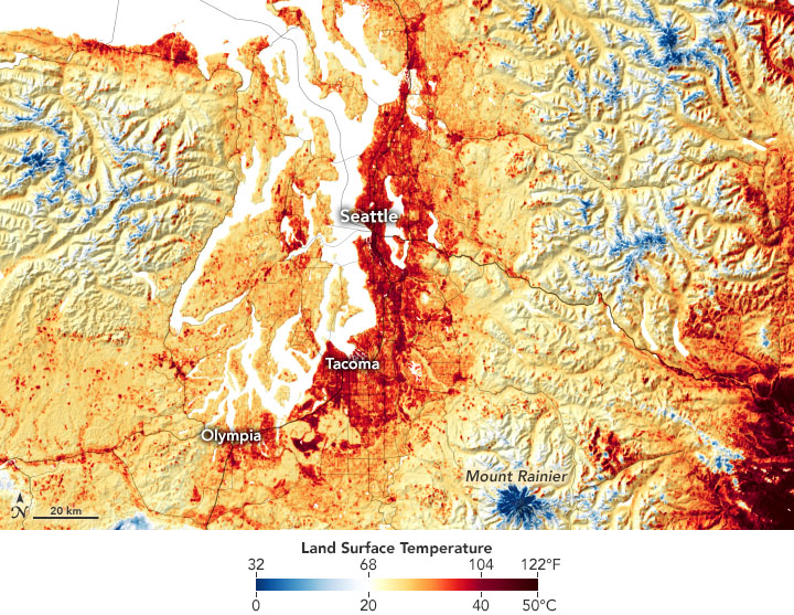
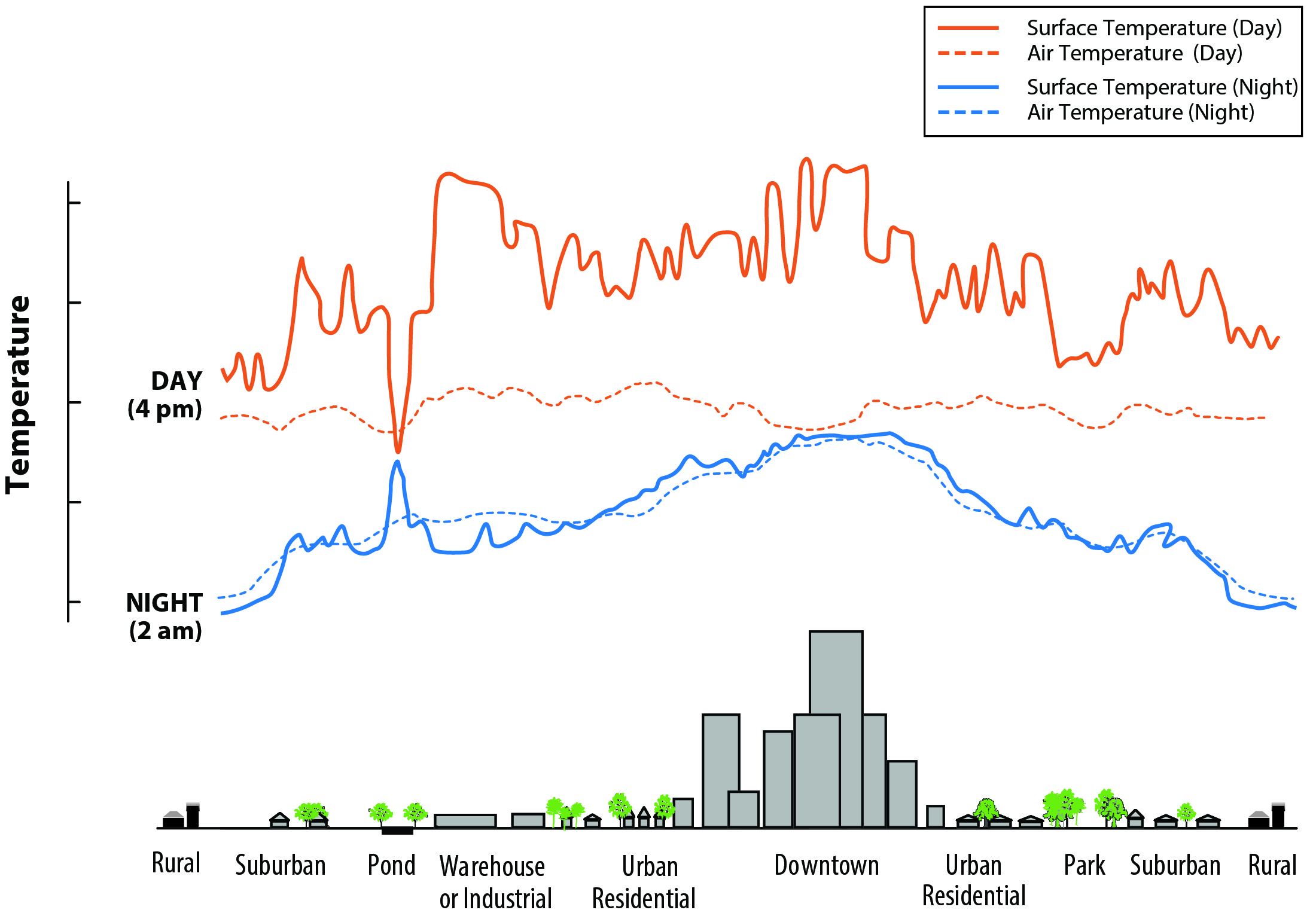
Urban heat islands are urban areas that are significantly warmer than surrounding rural areas. They form where there is limited greenery and a high density of heat-absorbing urban materials, such as concrete, asphalt, and buildings. Heat islands can occur in small or large cities and suburban areas, or anywhere with large extents of heat-absorbing surfaces and fewer trees. During the day, urban heat islands can be 1-7°F hotter than surrounding areas. These areas also retain heat, so that even nighttime temperatures can be 2-5°F hotter than surrounding areas.
There are several types of heat islands. Surface heat islands form because urban surfaces such as roadways and rooftops absorb and emit more heat than most natural surfaces. Atmospheric heat islands form when air in urban areas is warmer than air in outlying areas. They are much less variable than surface heat islands. Intra-urban heat islands are areas within a city that are hotter than other areas in the same city.
What causes heat islands?
According to the U.S. Environmental Protection Agency, heat islands form as a result of a number of factors, including:
- Fewer natural landscapes in urban areas. Trees, vegetation, and water can cool the air by providing shade, releasing water from plant leaves, and evaporation from bodies of water like lakes, rivers, and ponds. Impermeable surfaces (solid surfaces that do not allow water to penetrate, forcing it to run off) in urban areas such as sidewalks, roads, buildings, and parking lots provide less shade and moisture than natural landscapes and raise temperatures.
- Urban materials. Many materials used for pavements or roofing tend to absorb and emit more heat than trees, vegetation, and water. As such, heat islands accumulate heat throughout the day and become hotter after sunset due to the slow release of heat from urban materials.
- Urban layouts. The way buildings are laid out in a city can affect how the wind blows and how heat is absorbed and released. Buildings in highly developed areas retain heat longer than standalone buildings. Cities with many narrow streets and tall buildings become urban canyons, which can block natural wind flow that could bring cooling effects.
- Heat generated from human activities. Vehicles, air-conditioning units, buildings, and industrial facilities all emit heat into the urban environment. These sources of human-generated waste heat can contribute to heat island effects.
- Weather and geography. Calm and clear weather conditions result in more severe heat islands, whereas strong winds and cloud cover suppress heat islands. Geographic features can also impact the heat island effect. For example, nearby mountains can block wind from reaching a city, or create wind patterns that pass through a city.
The Northwest is getting hotter
Climate change is expected to raise temperatures and increase the likelihood of extreme events such as heatwaves, which could worsen urban heat islands. In the Northwest, the annual average temperature has risen nearly 2˚F since 1900 in Idaho, Oregon, and Washington. Alaska has warmed faster than any other state, with a 3˚F increase since 1925. Heat waves, like the 2021 heat dome, are also on the rise.
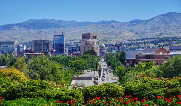
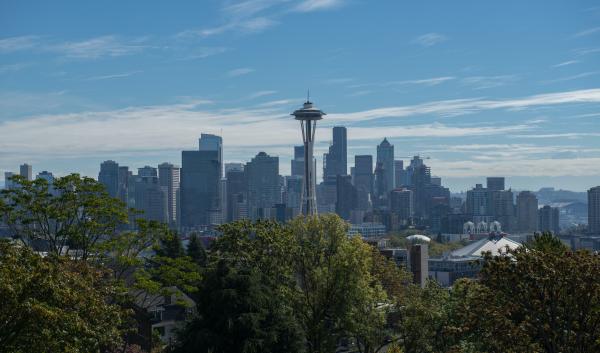
Urban areas are getting especially hot. Boise, in particular, is one of the fastest warming metropolitan areas in the country. In the last decade, Bend, Oregon and Seattle, Washington have scored in the top 20 cities with the highest urban heat island intensity in the United States. Contributing factors to heat island intensity include low percentages of greenery, low albedo (the amount of light a surface can reflect), and high percentages of impermeable surfaces. Urban growth is also a factor in increased urban heat. Urban areas are growing rapidly. With that growth comes an increase in impermeable surfaces such as roads and sidewalks, often at the expense of vegetated areas. Meanwhile, many smaller cities and towns across the region have also experienced record-breaking heatwaves and high temperatures.
Impacts of heat islands in the Northwest
Extreme heat is not only uncomfortable; it kills more people in the U.S. every year than any other weather event. Cities in temperate climates, like many cities in the Northwest, have a higher correlation with increases in mortality due to extreme heat, even when compared with hotter, southern cities. Extreme heat can also cause dehydration, heat exhaustion, and heat stroke. Many at-risk individuals, such as children, the elderly, and outdoor workers lack the resources needed to adapt (e.g., funds or ability to purchase an air conditioner or reach a cooling center). Heat and poor air quality can also limit outdoor exercise and stress-reducing activities, which can lead to decreased social interaction and increased mental distress.
Heat islands have a number of other impacts in urban areas, including:
- Increased energy consumption due to air conditioning
- Reduced air quality and increased greenhouse gas emissions caused by increased use of fossil fuels to meet energy demands
- Reduced water quality caused by warmer stormwater runoff
- Damage to urban gardens and farms
Low-income neighborhoods and communities of color are likely to experience higher levels of intra-urban heat island intensity. In many formerly redlined communities (a now-illegal practice from the 1930s when the federal government labeled non-White neighborhoods as undesirable for real estate investment), the development of industry came at the expense of environmental and public health. To this day, many formerly redlined communities have fewer natural landscapes and more urban heat islands. In Seattle, previously redlined communities are 2.1°F warmer than the city’s average, and in Portland, some previously redlined communities are 10.4°F warmer than the city’s average. According to Portland’s report on the impacts of the 2021 heat dome, 61% of the people who died lived in intra-urban heat islands.
What can be done to reduce urban heat islands?
With temperatures rising and extreme heat events becoming more common, urban areas will need strategies that can lower temperatures in intra-urban heat islands and keep residents cool and safe.
- Tree plantings. Trees and other plants can lower temperatures in shaded areas by as much as 10°F—a significant cooling effect that can protect individuals from heat-related illness and death. Neighborhoods with more canopy cover stay cooler.
- Cooling centers. These facilities are located within a city and are typically air-conditioned or cooled buildings that have been designated to provide respite and safety during extreme heat.
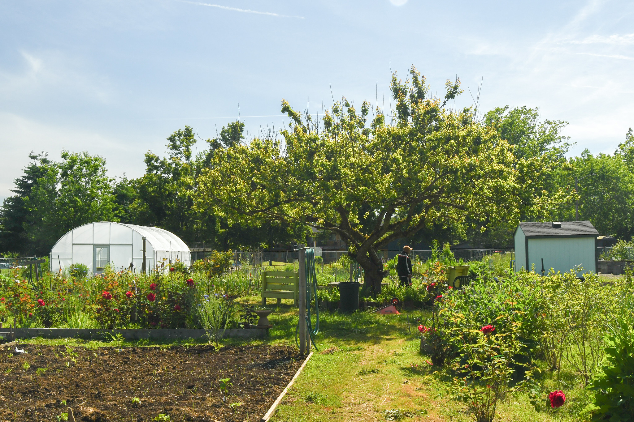
- Green roofs. Vegetative layers on rooftops reduce surrounding air temperatures and improve stormwater management. They provide shade and reduce heat through evapotranspiration. Green roofs can include rooftop gardens or farms, which can also increase local food security.
- Cool roofs. Roofs that are angled to reflect sunlight and heat away from a building can reduce roof temperatures and lower energy demands. Materials or coatings that reflect sunlight can also be added to cool roofs.
- Cool Pavements. Paving materials that remain cooler than conventional pavements cool the surface and surrounding air temperatures and reduce stormwater runoff. Cool pavements can include reflective coatings or grass pavings.
- Urban agriculture. As Northwest urban populations grow, cities can consider strategically placing urban agriculture plots to reduce heat island effects. Urban gardens can also have a cooling effect on surrounding areas.
- Preserving open space and farmland. Conservation of open space is an integral factor in reducing the surface urban heat island and is a way to mitigate the warming effects of most land-cover types associated with urban growth.
Urban planners can also consider smart growth practices to create, maintain, and alter neighborhoods. In the long term, creating walkable neighborhoods and designing compact buildings can reduce the carbon footprint of cities, and reduce the impacts of further climate change. Generating power from solar panels can also reduce energy costs, improve air quality, and provide shade and cooling in urban areas.
As the climate continues to change, urban heat will be an ever-present threat in Northwest cities and towns. However, there are adaptation actions that can keep residents cool and safe while improving urban climate resilience. In addition, government agencies, urban planners, and corporations can advance urban climate resilience with voluntary and incentive-based initiatives like those listed above and policy actions such as incentivizing green roofs for public buildings.
Heat.gov provides webinars and information on heat equity, urban heat islands, planning and preparation and at-risk groups from the National Integrated Heat Health Information System (NIHHIS).
EPA Urban Heat Islands Webpage provides additional information about urban heat islands, their impacts, and adaptation options.
Redlining and Urban Heat Islands Interactive Map provides information about redlining in many cities throughout the U.S. and demonstrates that many redlined neighborhoods overlap with heat islands.
Extreme Heat and Seattle-Area Urban Heat Islands is a webpage that describes the specific implications of urban heat islands in Seattle, Washington.
In the Hot Seat: Saving Lives from Extreme Heat in Washington State is a report from the University of Washington Climate Impacts Group that describes the problem of extreme heat and outlines specific, actionable guidance for short-term emergency response and long-term risk reduction in Washington.
Urban Heat Island Abatement in Portland is an Environmental Protection Agency report that investigates where urban heat occurs and how it can be mitigated in Portland, Oregon.
Heat Watch Report for Treasure Valley, Idaho is a report that identifies the hottest areas in Boise, Idaho and surrounding towns.
American Forests and U.S. Forest Service Vibrant Cities Lab arms people with the most current and comprehensive resources related to greening cities. The website helps people create, implement, and fund their urban forestry plans and related programs.
American Forests Tree Equity Score Tool provides a social-equity-focused narrative, goals, and a guide path for building understanding, commitment, and action around tree equity.
The Climate and Economic Justice Screening Tool is a geospatial mapping tool to identify disadvantaged communities that are marginalized, underserved, and overburdened by pollution.
Low Income Home Energy Assistance Program (LIHEAP) provides federally funded assistance to reduce the costs associated with home energy bills, energy crises, weatherization, and minor energy-related home repairs.
Weatherization Assistance Program is a Department of Energy program that reduces energy costs for low-income households by increasing the energy efficiency of their homes, while ensuring their health and safety.
Building Resilient Infrastructure and Communities (BRIC) program this Federal Emergency Management Agency (FEMA) program support states, local communities, tribes and territories as they undertake hazard mitigation projects, reducing the risks they face from disasters and natural hazards.
Read more from the Northwest Climate Hub:
-
This Adaptation in Action profile highlights Boise, Idaho’s tree planting campaign to reduce urban heat, offset greenhouse gas emissions and build more resilient forests across the city and state.
-
Urban forests in the Northwest can reduce urban heat islands, which can improve urban climate resilience and environmental justice efforts.
-

The 2021 heat dome caused record-breaking temperatures in the Northwest. Climate change increases the likelihood of heat waves like this.