

A series of tree species lists has been developed for ecoregions and states in the Northern Forests region to summarize anticipated changes in tree species habitat under climate change.
Tree species lists draw upon data from the Climate Change Tree Atlas, a tool produced by the USDA Forest Service Northern Research Station. Each handout describes variables that can be used to understand potential tree species' responses to climate change by location:
Remember that models are just tools, and they’re not perfect. Model
projections can’t account for all factors that influence future tree species'
success. If a species is rare or confined to a small area, model results may
be less reliable. These factors, and others, could cause a particular tree species
to perform better or worse than a model projects. Human choices will also
continue to influence forest distribution, especially for tree species that
are projected to increase. Planting programs may assist the movement of
future-adapted species, but this will depend on management decisions. Despite these limits, models provide useful information about future
expectations. It’s perhaps best to think of these projections as indicators of
possibility and potential change. The Climate Change Tree Atlas is available online for more detailed information on habitats throughout the eastern region. The Atlas provides information on species characteristics, life history, and current distribution for each species. Users can see which factors (e.g. temperature, elevation, soil properties) help to drive species distributions, offering some guidance on species sensitivity to large-scale climate differences. The Atlas offers maps and numerical summary data that show how each species' suitable habitat is projected to change under three different climate models, for both high and low emissions scenarios. Additionally, maps depicting the colonization likelihood of potentially suitable habitats are provided for some species. If the summaries below do not cover the geography needed, visit the Climate Change Tree Atlas website for summaries by National Forest, National Park, HUC6 Watersheds, Ecoregional Vulnerability Assessments (EVAS), USDA Forest Service EcoMap 2007 Sections, National Climate Assessment (NCA) 2016 Regional areas, 1 x 1 ° Grid, the Eastern United States, and Urban Areas.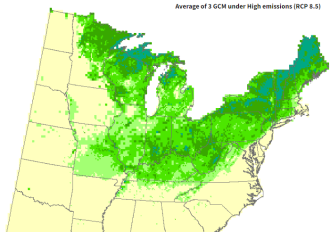
Browse Climate Change Projections For Individual Tree Species By Ecological Sections
-
Minnesota Tree Species
There are 9 ecological section handouts for Minnesota. There is also a summary handout for northern Minnesota.
-
Michigan Tree Species
There are 9 ecological section handouts for Michigan. There are also summary handouts available for northern Michigan, southern Michigan and western upper Michigan.
-
Wisconsin Tree Species
There are 3 ecological section handouts for southern Wisconsin and 7 ecological section handouts for northern Wisconsin. There are also summary handouts available for southern Wisconsin and northern Wisconsin.
-
Iowa Tree Species

There are 9 watershed handouts for Iowa.
-
Central Hardwoods Tree Species

There are 3 central hardwoods handouts for Illinois, Indiana, Missouri. There is one statewide summary for Indiana.
-
Central Appalachian Tree Species
There are 2 ecoregion handouts for Ohio, 3 for West Virginia, and one for Maryland. There is one summary handout for the Central Appalachian region.
Mid-Atlantic Tree Species
There are 5 ecoregion handouts for Pennsylvania. There is one ecoregion handout for New Jersey, Delaware, and eastern Maryland. There is one ecoregion handout for southern New York. There is one summary handout for the Mid-Atlantic region.
New England Tree Species
There are 3 ecoregion handouts covering Connecticut, Maine, Massachusetts, New Hampshire, northern New York, Rhode Island, and Vermont. There is one New England summary handout.
Urban Forest Ecosystem Vulnerability Assessments

Visit the urban forest vulnerability home page for city specific assessments in the Midwest and Northeast region.
Regional Forest Ecosystem Vulnerability Assessments
Visit the vulnerability home page for regional vulnerability assessments for these regions.